Top Stories
Urgent Weather Update: Warm Saturday with Rip Current Risks
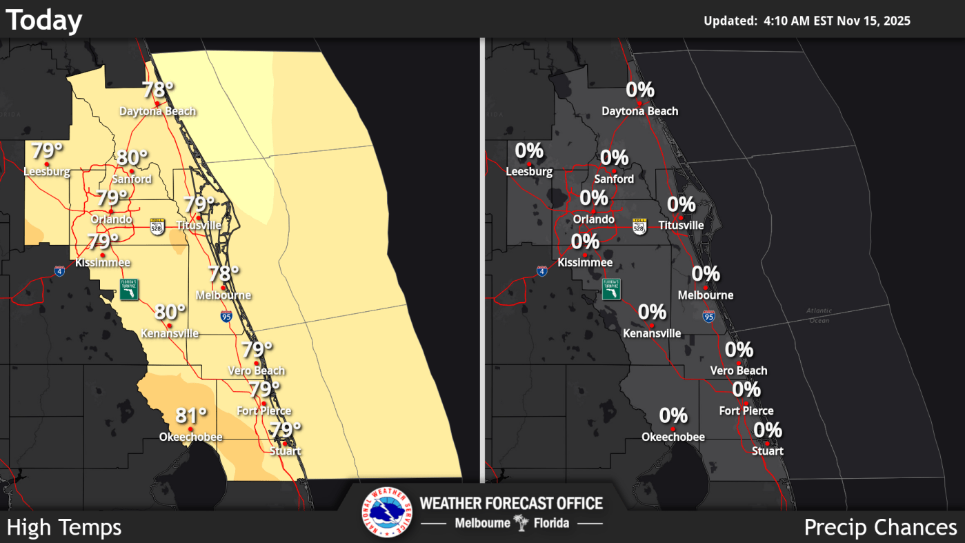
UPDATE: A warm Saturday is unfolding across Central Florida with temperatures soaring into the 80s, marking a significant shift from the cooler weather experienced this week. As of 8:00 AM today, temperatures are reported at around 60 degrees, accompanied by light clouds and a gentle northward breeze blowing at 5 mph, as confirmed by the National Weather Service (NWS) Melbourne.
However, beachgoers should exercise caution! Authorities have issued a moderate risk for rip currents at all Atlantic beaches in the region, urging swimmers to remain vigilant. This risk is particularly concerning as more residents flock to the coast to enjoy the warmer weather.
As the day progresses, temperatures are expected to peak around 3:00 PM before dropping to approximately 56 degrees in the evening. Winds will shift to an east-southeast direction, providing a cooler breeze as night approaches.
This weather shift not only invites outdoor activities but also poses risks for those heading to the beach. The NWS emphasizes the importance of adhering to safety guidelines to ensure a safe and enjoyable experience for all.
Residents are encouraged to make the most of this beautiful Saturday while staying informed about local weather conditions and beach safety. Stay tuned for further updates as conditions develop throughout the day.

Trump Issues Ultimatum to Maduro as Venezuela Closes Airspace

Microsoft Struggles to Fix Windows 11 Amid Ongoing User Frustration

Bottineau Man, 88, Dies in Central North Dakota Crash

Macaque Monkeys Tap to the Beat, Challenging Musical Learning Theories

Organizing Committee Prepares for 2034 Olympics at Quarterly Meeting

Kino Lorber Acquires Argentine Film ‘The Currents’ for 2026 Release

Dozier’s BBQ Expands to Houston’s Downtown with New Stall

Grab McFarlane’s Warhammer 40,000 Space Marine at 20% Off

Organizing Committee for 2034 Olympics to Meet Tomorrow Morning

Urgent Update: Tom Aspinall’s Vision Deteriorates After UFC 321

MIT Scientists Uncover Surprising Genomic Loops During Cell Division

University of Hawaiʻi Joins $25.6M AI Project to Enhance Disaster Monitoring

AI Disruption: AWS Faces Threat as Startups Shift Cloud Focus

Time Crystals Revolutionize Quantum Computing Potential

Honeywell Forecasts Record Business Jet Deliveries Over Next Decade

Discover the Full Map of Pokémon Legends: Z-A’s Lumiose City

GOP Faces Backlash as Protests Surge Against Trump Policies

Parenthood Set to Depart Hulu: What Fans Need to Know
-
 Top Stories1 month ago
Urgent Update: Tom Aspinall’s Vision Deteriorates After UFC 321
-
 Health2 months ago
MIT Scientists Uncover Surprising Genomic Loops During Cell Division
-
Science4 weeks ago
University of Hawaiʻi Joins $25.6M AI Project to Enhance Disaster Monitoring
-
 Top Stories2 months ago
AI Disruption: AWS Faces Threat as Startups Shift Cloud Focus
-
 Science2 months ago
Time Crystals Revolutionize Quantum Computing Potential
-
 World2 months ago
Honeywell Forecasts Record Business Jet Deliveries Over Next Decade
-
 Entertainment2 months ago
Discover the Full Map of Pokémon Legends: Z-A’s Lumiose City
-
 Top Stories2 months ago
GOP Faces Backlash as Protests Surge Against Trump Policies
-
 Entertainment2 months ago
Parenthood Set to Depart Hulu: What Fans Need to Know
-

 Politics2 months ago
Judge Signals Dismissal of Chelsea Housing Case Citing AI Flaws
-

 Sports2 months ago
Yoshinobu Yamamoto Shines in Game 2, Leading Dodgers to Victory
-

 Health2 months ago
Maine Insurers Cut Medicare Advantage Plans Amid Cost Pressures